August 19, 2010
Surf your way to a deep-ocean research expedition
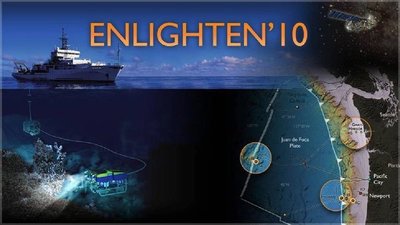
Journey 300 miles off the Washington-Oregon coast and dive nearly a mile deep into the ocean as scientists and 20 students use underwater robots to explore, map and sample methane ice deposits, an underwater volcano and seafloor hot springs spewing water up to 570 degrees F.
Just click yourself aboard, thanks to the Internet. On the Enlighten ’10 expedition website, images are being updated each day of the four-week expedition and short documentary-style videos will be posted.
While at the site, don’t miss seeing preparations for the ship’s departure “performed” to Flight of the Bumblebee, the first dispatch from the chief scientist and, under the “Arts” heading, the poetry and octopus ballet. Yes, along with all the science topics, there is a section for the arts, celebrating such events as the Bosun’s Poetry Night.
The expedition, under way through Aug. 23 on the UW’s vessel Thomas G. Thompson, is laying the groundwork for a $126 million seafloor observatory comprised of science nodes, moorings and instruments all connected to land with a cable for power and real-time, high-speed, two-way communications.
The UW is leading development of this cabled project called the Regional Scale Nodes. It’s part of the National Science Foundation’s Ocean Observatories Initiative and represents a major investment by the foundation in new approaches to science in the ocean basins. The Ocean Observatories Initiative is managed by the Consortium for Ocean Leadership in Washington, D.C., and other partners include Woods Hole Oceanographic Institution, Scripps Institution of Oceanography, Oregon State University and the University of California, San Diego.
“In time, hundreds of sensors on the seafloor and on fully instrumented water-column moorings will be deployed at sea and controlled by shore-based personnel, thanks to the electrical power and high-bandwidth telecommunications capabilities provided by this cabled network,” said Deborah Kelley, UW professor of oceanography and co-chief scientist on the cruise. The main cable carrying data and power will come ashore in Pacific City, Ore., and connect to high-speed Internet in Portland.
Work led by Oregon State University scientists also is being conducted during the Thompson expedition to define several coastal components of the Ocean Observatories Initiative.
Other participants on the current expedition come from Arizona State University, and groups from Woods Hole are providing support for the remotely operated vehicle Jason and the autonomous underwater vehicle Sentry, both cutting-edge platforms for conducting high-resolution mapping of the seafloor, according to Kelley.
At times, live video will be streamed from the seafloor showing exotic life forms or scientists at work on the ship. When visiting the website check the “Webcast: Streaming Live from the Sea” link to see if scientists are using the high-definition underwater video camera for mapping and surveying. The webcast allows you to watch over their shoulders and occasionally hear commentary.
“By 2014, the 800-kilometer network of fiber-optic and electrical cables and instruments will allow scientists, educators, students and the public to observe and interact with the oceans via the Internet in entirely new ways, 24/7, for decades,” said John Delaney, UW professor of oceanography and chief scientist on the cruise. “The Regional Scale Nodes is one of the first such systems — by 2020 there are likely to be many such installations across the global ocean,” says Delaney, who has recently traveled to more than 10 countries to discuss the project.
Tag(s): Deborah Kelley • John Delaney • Ocean Observatories Initiative • Regional Scale Nodes • RV Thomas G. Thompson


