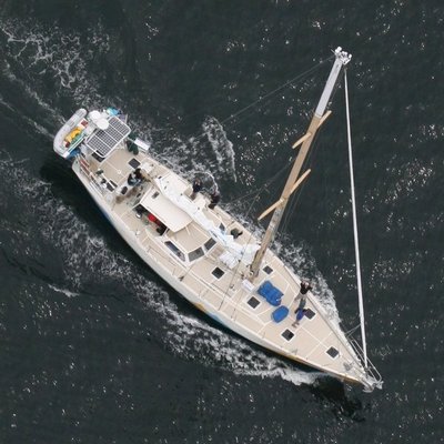
UW scientists are leads for five of the eight science projects on board a 64-foot boat that is sailing 25,000 miles all the way around North and South America.
The point is to raise awareness about the plight of the oceans, according to a press release from sponsors Pacific Science Center and Sailors for the Sea, a nonprofit that enlists the boating community to protect and restore oceans and coastal waters.
The expedition, being called “Around the Americas,” is on a 13-month journey that will take the ship Ocean Watch to a dozen countries.
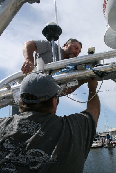
UW scientists with the Applied Physics Laboratory and Joint Institute for the Study of the Atmosphere and Ocean have partnered with the Around the Americas voyage. They are taking advantage of the trip to gather data on such things as conditions in the Arctic Ocean and how dust, smoke and moisture in the atmosphere can decrease the amount of sunlight that reaches the Earth — something not routinely gathered at sea. Among the instruments they’ve installed is a six-eye digital camera that’s unlike anything used for oceanographic observation before.
“The Around the Americas cruise is an adventure in hands-on science that provides a thrilling opportunity for UW scientists to help increase awareness of the plight of the oceans and gather useful scientific data at the same time,” says Andy Jessup, a principal oceanographer with the Applied Physics Laboratory who leads a group involved in remote sensing that had a key role in the instrumentation of the vessel.
The vessel Ocean Watch can be used to collect something scientists call “datasets of opportunity,” the expedition Web site says. “Essentially, instruments are used when opportunities present themselves. The Around the Americas voyage is a unique opportunity for scientists to collect new types of data and to test new methods and equipment.”
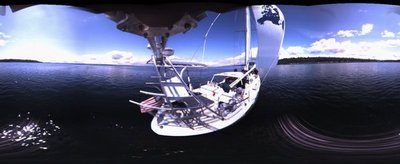
An example is the system developed by Dan Clark, an engineer with the Applied Physics Laboratory, to take “snapshots” of the ocean surface and out to the horizon in all directions once every 10 seconds, generating more than 86,000 separate images each day. The camera can also be triggered by those on board when, for example, the expedition encounters whales, unusual weather and storms, and the camera takes images at a nearly video-camera rate.
Clark put an off-the-shelf six-eye digital camera on a moveable boom six feet above the deck that extends out over the water and can be retracted for maintenance and storms. The images are fed to a computer that “stitches” them together in various arrangements. The data are stored on hard drives that will be sent to the Applied Physics Laboratory when the ship is in port.
When the lab’s Peter Dahl, a principal engineer, learned about the camera, he thought what was needed was a way to also record sounds. He arranged to have a hydrophone on board so it will be possible to detect and record such things as erupting seafloor volcanoes, noises in the water near ports, snapping shrimp found in southern waters and whale calls.
“Maybe you’ll pick up a whale and then you can throw the hydrophone sensor overboard and get an acoustic sampling,” Clark says in one of the expedition’s blogs. “And you can put the camera in burst mode and you’ll have a visual sample. I don’t think anybody’s done that before. There are a lot of different combinations since we have so many tools on board. That’s what happens when you take cutting edge technology and you push it into areas you’ve never seen before.
“It might be today that we’re thinking of clouds and jellyfish and wave breaking for fundamental physics but in a year we may come back and say, ‘Did we see any marine mammals when you guys went through Juneau, because there’s something going on there right now.'”
The sailboat may only be 64 feet long but its meteorological sensor package is so sophisticated it rivals ones used on research vessels four or more times that size, says Jessup. The meteorological measurements help scientists learn how much ocean waters are heating because of the sun.
Information and blogs about the expedition are at http://www.aroundtheamericas.org/, a Web site by the UW’s Center for Environmental Visualization that involved creating all the seafloor maps seen on the site and ways for those on the vessel to post content as events unfold.
Other UW projects during the cruise will involve deploying buoys in the ice when crossing the Arctic Ocean for the International Arctic Buoy Program led by APL’s Ignatius Rigor; surveying jellyfish populations, with APL’s Bill Asher as the principal investigator; and using a hand-held sun photometer to measure how much sun is being reflected away by such things as dust and water droplets in the atmosphere, with principal investigator Tom Ackerman of the Joint Institute for the Study of the Atmosphere and Ocean.
Each leg of the journey has a scientist on board and when the vessel sails across the Arctic Ocean, UW’s Harry Stern will be on board. Stern, a mathematician with the Applied Physics Laboratory who works on such things as determining ice motion and thickness using remote sensing, will conduct scientific observations and ensure all the instruments are operating. He’ll be on board from late July to early September as the vessel travels through the Northwest Passage, down Baffin Bay to St. Johns, Newfoundland.