July 9, 2009
Western Washington appears poised for another extremely dry summer
If you feel as if Western Washington has had an unusually dry start to the summer this year, you’re not mistaken.
The extended dry spell from May 20 to July 4 this year in most of Western Washington means the region has already been drier than the period May 20 to July 4 of what turned out to be the driest summer on record.
The last time any significant rain fell in most of Western Washington this year was May 19.
“Essentially summer started abruptly in Western Washington on May 20,” says Phil Mote, research scientist with the University of Washington’s Climate Impacts Group.
Mote and UW research scientist Karin Bumbaco this week asked the National Weather Service to use its applied climate information system to compare this year’s precipitation from May 20 to July 4 to the same period in years past for the four Western Washington weather stations that keep daily records.
At every station, that 46-day period this year was the driest on record.
• Seattle Tacoma International Airport
0.18 inches this year
0.64 inches was the previous record, set in 1965
0.79 inches fell from May 20 to July 4 in 2003, the driest summer on record
• Quillayute
1.25 inches this year
1.61 inches was the previous record, set in 1972
2.03 inches fell in 2003, the driest summer on record
• Olympia
0.23 inches this year
0.40 inches was the previous record, set in 1965
0.41 inches fell from May 20 to July 4 in 2003, the driest summer on record
• Hoquiam
0.40 inches this year
0.78 inches was the previous record, set in 1965
0.89 inches fell from May 20 to July 4 in 2003, the driest summer on record
Summer records of precipitation typically includes precipitation for the months of June, July and August.
While most of Western Washington was quite dry, there were exceptions. Vancouver and Clark County received more than an inch of rain June 19 and some areas of the western Cascades, such as North Bend, had more than an inch of rain that same day.
Areas with low precipitation are a concern because new UW research shows that it’s the amount of precipitation — not just snow pack — that largely determines river flows in late summer in Western Washington, Mote says.
For example during the summer of 2003, nearly all Western Washington rivers had record low flows in late August and early September.
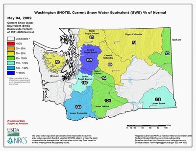
“We’re particularly concerned about the northern Cascades and Olympic mountains because those areas were already dealing with lower than normal snowpack before this dry spell,” Mote says. As of April 1, snowpack in those two regions was 67 to 77 percent of normal.
That low snowpack has already caused the Northwest River Forecast Center to alert river users that, for example, streamflow for the Okanogan River near Tonasket; Similkameen River near Nighthawk; and the Methow River near Pateros could be 50 to 75 percent of usual flows through Sept. 1. Other rivers in the area of concern — for example the Dungeness River near Sequim and Skagit River near Concrete — are forecast to have flows that are 75 to 90 percent of normal.
While Eastern Washington has had its dry spots, Spokane — which is usually drier than Seattle — was wetter than Seattle and had 100 percent of its normal precipitation
Mote and Bumbaco, Washington’s climatologist and assistant climatologist respectively, are attending the annual meeting of the American Association of State Climatologists this week in Grand Rapids, Michigan. They will contrast Western Washington with places such as Daytona Beach, Florida, that had its wettest May on record with 22.35 inches, which is 10 inches more than the previous record.
###
For more information:
Mote, cell 541-913-2274
Bumbaco, cell 206-518-4097


