 |
Lesson Three:
|
 |
European and American Exploration of the 18th-Century Pacific Northwest |
|
|
|
|
|
|
|
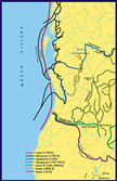
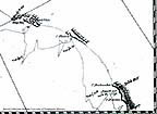
Click on the map icon, right, to see a larger view of British explorations |
 |
|
|
|
|
In the century between the 1740s and the 1840s, different nations competed with one another, and with native peoples, to take control over the area that is today known as the American Pacific Northwest and the west coast of Canada. In one sense this competition had begun in 1492, when Columbus landed in the New World, claimed it for Spain, and inaugurated a European rivalry for territory. Over the next two years, the Pope responded to the discovery and the threat of competition over it essentially by dividing the western hemisphere into Spanish and Portuguese zones of influence, and assigning the Pacific Northwest to Spain. Yet Europeans would not actually see Alaska and the Pacific Northwest until the 18th century, when their ambitions spurred one another to explore the territory. The contest ended in 1846, when the Americans and British divided most of the region between themselves by drawing a boundary between Canada and the United States at the 49th parallel; another key event occurred when Russia sold Alaska to the United States in 1867. It thus took more than three and a half centuries for peoples of European descent, following up on Columbus’s first voyage, to establish some degree of mutually respected authority over the Pacific Northwest (and for decades longer, even that authority remained contested by native peoples). This long span of time illustrates just how isolated the region once was from European centers of power.
The period 1774-1795 marked an especially intense era in this rivalry, for it was when sailors from different nations first visited the lands between Alaska to the north and California to the south, and engaged their countries directly in a contest over who would control the territory. The Spanish arrived first, in exploratory voyages of 1774 and 1775, and performed ritual acts of possession that asserted their claim to the territory. The British soon followed, with the first ship arriving in 1778 and many more coming thereafter. Other nations also made appearances in this period: the United States, a relatively weak competitor, showed up belatedly; Russia coveted lands south of Alaska but never really established an effective claim to any (except at Fort Ross in California, between 1812 and 1841); and France sent only a single exploratory expedition in this era. But Spain and Great Britain were the main contestants, and the nature and outcome of their rivalry loom large in understanding the European forces increasingly at work on the coast of the Pacific Northwest.
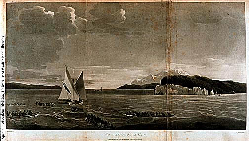
Entrance to the Strait of Juan de Fuca (left). John Meares, Voyages made in the Years 1778-1812. London, 1790. Atlas, plate 7. Sketch by T. Strothard.
Carlos Schwantes, in The Pacific Northwest: An Interpretive History (p. 42), comments that before 1774 Spain “showed little interest in a region that seemed so pitifully lacking in either economic resources or good harbors,” and had to be roused from “her imperial lethargy” by Russian advances toward Alaska. These comments don’t portray Spanish colonization very fully. Between the time of Columbus and the later 18th century, Spain was the most successful colonial power in the Americas, occupying most of the coasts of Central and South America as well as the Gulf of Mexico, and extracting enormous wealth from such places as Mexico and Peru. When Russian voyages to Alaska in the 1720s and 1740s threatened the North Pacific coastline that Spain claimed, they motivated Spain to send expeditions to the Northwest Coast, as well as to establish missions, forts, and towns along the California coast. But Spanish interest in the lands that would become the west coast of the United States and Canada was not initially focused on its economic potential or prospective harbors. Rather, Spanish officials intended to secure the region--or at least its coastline--as a buffer zone between possible Russian colonies to the north and Spain’s main center of imperial activity (not lethargy) in Mexico.
Consider how Spanish officials in Mexico justified the exploratory voyages of the mid-1770s. First, they used religion to explain their presence along the Northwest Coast. (“Christianity” should be added to the “three C’s of empire” that Schwantes mentions [p. 42].) Rather than let the Russians or English try to convert the Indians, Spain hoped that the natives would be “drawn into the sweet, soft, desirable vassalage of His Majesty” [the King of Spain] and “bathed in the light of the Gospel by means of spiritual Conquest, to separate them from the utter darkness in which they live and show them the road to eternal salvation.” Using the well-rehearsed rhetoric of European colonization, the Spanish basically claimed that Indians would benefit greatly from their arrival. Second, they also claimed that the Indians would do much better as Spanish vassals than as vassals of England or Russia. The Spanish insisted that they were not sailing to the Northwest Coast simply to expand their territory. And in truth, they were having enough trouble as it was trying to populate the northern frontier of Mexico, including California; they had no interest in trying to send settlers to the Pacific Northwest, or in trying to develop its economic resources. They went there, an official explained, “not because the king needs to enlarge his realms, as he has within his known dominions more than it will ever be possible to populate in centuries, but in order to avoid the consequences brought by having any other neighbors [there] than the Indians.”
It is important to understand that the Spanish did not sail north from Mexico seeking economic resources or good harbors. They never sent any traders to the Northwest coast, or even any missionaries to the Indians there. They simply meant to assert a right to the territory, in the hope that reinforcing their claim dating from the 1490s would somehow prevent or discourage other European powers from doing the same thing. The ceremonial nature of this assertion—landing at a few selected points on the coast, erecting a cross, burying a bottle containing official documents at the foot of the cross, and then departing—suggests just how limited their vision of colonizing the territory was. Moreover, the Spanish found it quite difficult, given the limited means of its navy, actually to sail northward along the coast from Mexico. In the end, they could and would not mount a claim to the region in a way that we today, and that other nations at that time, would recognize as assertive. But this does not mean that the Spanish were lethargic colonists; it suggests rather that their attention lay elsewhere, especially in Mexico, from which they had been extracting wealth aggressively for more than two centuries.
Section of chart (right) showing Cook's 1778 voyage along the North West Coast. Area displayed is from Cape Gregory to Cape Edgcombe.
Consider by contrast the British approach to the Northwest. As Schwantes explains (pp. 19-24), the British first arrived in the region as a byproduct of their search for something else—a Northwest Passage through North America that would expedite travel and trade between Europe and Asia. Cook’s crew was initially uninterested in the Pacific Northwest in its own right. But as soon as the British discovered--again, almost by accident--the economic value of sea otter pelts to Chinese markets, they hustled back to the Northwest Coast to do more trading and exploring. The Spanish sent only a handful of expeditions from Mexico to the Pacific Northwest between 1774 and 1795; these vessels came to claim, defend, and explore the territory, but never to do business there. The British, by contrast, sent 25 vessels in the decade 1785-1794; all but a few of them went primarily to participate in the maritime fur trade. In contrast to the Spanish, the British were on the lookout for economic resources and good harbors almost from the beginning of their exposure to the Pacific Northwest, and they approached colonization of the territory more aggressively.
The different designs of the Spanish and British led directly to the Nootka Sound controversy of 1789-1794, a crisis in which Spain and Britain challenged one another’s claim to the Pacific Northwest (see Schwantes, pp. 47-48). The crisis started in 1789 when Spaniards tried to defend their claims to the territory by capturing British trading vessels as they arrived at Nootka Sound, on the west coast of Vancouver Island. The British seized upon this incident, and talked about going to war over it, because they saw it as an opportunity to promote a different approach to colonization in the Americas. Spain should not be permitted simply to claim territory and prevent other Europeans from doing the same, the British argued, unless it was actually occupying and making use of the territory. In essence, Britain wanted to change the “rules” of colonization more to their favor. Rather than rely upon the edict of the Pope or some ritual act of possession to assert control over territory, it insisted, relatively unoccupied lands ought to be accessible to any nation that could make productive (i.e., economic) use of them. This concept of colonization was written into the Nootka Sound Convention (signed in 1790, amended in 1794), which resolved the controversy between Britain and Spain.
These new rules, of course, clearly favored Britain over Spain. They were in a sense (and to oversimplify) an attack by the “new” Europe against the “old.” Spain’s approach to colonization in many ways dated from the 15th and 16th centuries. It depended heavily upon big and rather inflexible institutions—especially the crown, the military, and the Catholic church—and offered little in the way of incentives or opportunities to common individuals. Its mercantilist economic thinking emphasized the accumulation of bullion in Spain. Great Britain, by contrast, had traveled further down the path of modern capitalism. It was much more commercial and industrial in its orientation, and therefore more capable of manufacturing and transporting trade goods to the Americas. Britain was also a somewhat more democratic society, which meant among other things that it offered more opportunity to individuals hoping for economic gain and social mobility, and that certain commercial interests could pressure the government to follow a foreign and military policy more favorable to “free trade” (or at least freer access to non-European resources). For what it is worth, Britain was also a Protestant nation, in contrast to Catholic Spain, and a stronger maritime power. We might view it as more “modern” and less “medieval,” although again this is oversimplifying things. In any case, the two nations’ approaches to the Pacific Northwest illustrated different kinds of European societies. By the late 18th century, Britain’s distinctive traits gave it certain advantages over Spain in the contest for territory on the Pacific Rim, and enabled it to win access to an area that the Spanish had long claimed as theirs.
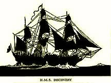
Resolution of the Nootka Sound affair provided an opportunity for Captain George Vancouver to visit the Pacific Northwest. After signing the convention in 1790, each nation sent envoys to Vancouver Island to implement locally the terms of the agreement. Spain dispatched Juan Francisco de la Bodega y Quadra, who had sailed along the Northwest Coast in 1775. The British sent Vancouver, who had sailed to the Northwest under Cook in 1776-1778. During this voyage, Vancouver and his crew undertook detailed exploration of the Northwest coastline that included a tour approximately 100 miles up the Columbia River as well as the first recorded non-native visit to Puget Sound. That visit to the Sound is the subject of the reading excerpted from Vancouver’s Voyage of Discovery and introduced below.
To gain additional background on exploration in this period, one might compare Vancouver’s perceptions to those of others at roughly the same time. Accompanying Vancouver aboard his two ships were a number of individuals, including Peter Puget, who also left accounts of what they saw and thought. At roughly the same time, Spanish explorers were also sizing up the region anew. (Initially, the Spanish reacted to the Nootka Sound convention by establishing a more active presence in the vicinity that included sending more vessels northward from Mexico.) See, for example, Jose Mozino’s Noticias de Nutka: An Account of Nootka Sound in 1792 for a Spanish scientist’s depiction of the region.
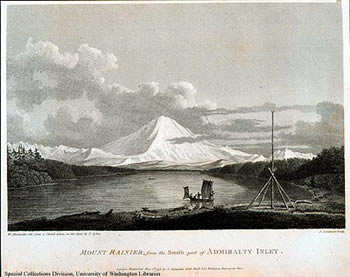
Mt. Rainier from the south part of Admiralty Inlet (right). Sketch by John Sykes. (University of Washington Special Collections)
GEORGE VANCOUVER
George Vancouver was born June 22, 1757 at King's Lynn, Norfolk, England. At the age of 13 he joined the Royal Navy and served as a midshipman during Captain James Cook's second and third voyages to the Pacific Coast (1772-75 and 1776-80). He thus accompanied Cook on his visit to the Northwest Coast in 1778. Following nine years of service in the West Indies the British government assigned to him a three-fold mission: to implement the Nootka Sound Convention, to explore the Pacific waters of North America, and to locate a Northwest Passage through British North America. Vancouver commanding the Discovery, and William Broughton on the Chatham, left England on April 1, 1791 and sighted the west coast of North America in April of 1792, close to the time when the American Robert Gray first located the mouth of the Columbia River. Vancouver and his crews meticulously surveyed and documented the Pacific Coast from San Francisco to Vancouver Island, including Puget Sound, so named for crew member Peter Puget. Vancouver's survey's proved that an easily navigable Northwest Passage did not exist, but in the process he named innumerable Pacific Northwest landmarks. He also strengthened British claims to the territory and left behind detailed records of the coastline for later navigators. His account suggests that he was constantly aware of his Spanish and American rivals. Vancouver returned to England on October 20, 1794, and died in 1798 at the age of forty. His brother published the account of the voyage, including maps, texts, and illustrations following the explorer's death. (For more information see Robin Fisher, Vancouver's Voyage: Charting the Northwest Coast, 1791-1795. Vancouver: Douglas and McIntyre, 1992.)
| Course Home | Previous Lesson | Next Lesson |