Lesson Sixteen: Mastering Nature: The Rise of Seattle, 1851-1930
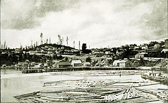
Seattle from the waterfront, 1878 (right). (Special Collections Division, University of Washington, neg. 23270; copy by Asahel Curtis. Orig. neg., Washington State Historical Society, Tacoma.)
The cities of the Pacific Northwest competed energetically with one another to gain dominance in the region. As discussed earlier (Lesson 13), Portland enjoyed advantages, related largely to its ability to command the largest hinterland, that gave it an early and enduring lead over prospective rivals. Seattle, by contrast, had to play catch-up. In 1880, its population was about 3500 people fewer than Walla Walla possessed and about one-fifth the size of Portland. Many predicted that Tacoma, assured of becoming the terminus of the Northern Pacific Railroad, would shortly surpass Seattle and live up to its (Tacoma's) slogan, The City of Destiny. Yet by 1920, in spite of its apparent handicaps, Seattle had passed its rivals to become the dominant city of the Pacific Northwest. Its population had leapt to 315,312 by 1920, while Portland's stood at 258,288 and Tacoma's at 96,965.
Nature Literally Harnessed (below): Postcard advertising the Alaska-Yukon-Pacific Exposition held in Seattle in 1909. (Courtesy, Museum of History and Industry, Seattle.)

One key to Seattle's success was the ability of its residents and promoters to master nature. Railroads permitted this mastery in one sense. They linked Seattle to the coal mines east and south of Lake Washington and to farms in eastern Washington. Railroads also ensured that when gold was found in the Yukon and Alaska during the 1890s and 1900s, Seattle would become the metropolis for those hinterlands—although its connections to the north were made by sea rather than by land. At the same time that Seattle rose to greater prominence by mastering nature at some distance, it undertook concerted efforts to master nature more locally. In order to grow and flourish as a city, it developed a network of streetcars that dispersed residents; acquired a water supply and an electric system by harnessing the Cedar and Skagit Rivers; leveled the hills surrounding downtown in order to facilitate real-estate development; straightened the channel of the Duwamish River and created a man-made harbor; built a new ship canal and locks that tied Lake Washington more directly to Puget Sound; and laid out a large-scale urban park system. In sum, the city flourished by harnessing to its own ends the many forms of nature that surrounded it.
This treatment of nature began early on in the town's history. The city was begun in 1851 at Alki Point, in what now is West Seattle. Some if the founding party, after one winter there, decided that Alki Point's windy and cold weather, coupled with a relatively poor harbor, made it an unpromising place to lay out a town. The next year some of the settlers moved to a more sheltered site, on the eastern shore of Elliott Bay, where the modern city of Seattle was begun. This site was not perfect, either; the steep hills rising from the water would complicate the process of building a city. But it was more sheltered from the wind and had deeper water for a harbor; and loggers could cut the trees on the hillside and easily slide them down to mills on the waterfront.
The town had its start, but it was hardly a respectable one. One observer in the 1850s summarized Seattle:
"Cut out a clearing from a dense forest on a side hill, one mile long and a quarter of a mile wide, put about fifty houses in this clearing; divide the settlement into two streets filled with sawdust; give the place three hotels, five boarding houses, and seventeen grog shops, and you have a clear idea of Seattle."
As the proportion of grog shops suggests, life was crude and heavily male. Men outnumbered women by a ratio of 5 or 10 to one. Indeed, this gender imbalance lasted a long time; as late as 1920, Seattle's ratio of men to women was 1.14 (while Portland's was 1.05 and Spokane's 1.00). In contrast to early Portland and Walla Walla, early Seattle was not much affected by the presence of missionaries.
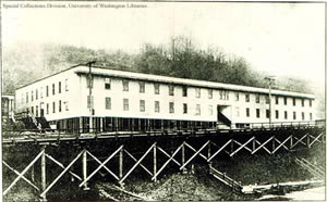 Mayor Hiram C. Gill sanctioned and approved the construction of the "largest house of prostitution in the world" on 10th Ave. S. in Seattle (right). (Special Collections, University of Washington, Social Issues Files Ha, neg. 8235)
Seattle business leaders had thought that their city might wither if it did not become the terminus of the Northern Pacific Railroad. Yet when the transcontinental line was finally completed to Tacoma, Seattle benefited along with its rival to the south. The population grew from 3,500 in 1880 to 42,800 in 1890, and by the early 1890s the city was substantial enough to attract its own transcontinental railroad, the Great Northern, which was finished in 1893. This railroad gave the city a tool with which to reach out and secure more of a hinterland for itself. But the biggest windfall came because the railroad enabled Seattle to claim a new hinterland to the north—Alaska and the Canadian Yukon. Prior to the 1890s, the city of San Francisco had controlled American trade with and industry in Alaska, but in the early 1890s Seattle began taking this hinterland away from San Francisco. It was cheaper and quicker to ship goods from Alaska to Seattle than to San Francisco, and after 1893 the Great Northern line permitted Seattle to ship those goods as easily to the East as San Francisco had been shipping them. One San Francisco firm moved its Alaska operations north to Seattle, while other new companies, including the Alaska Steamship Company, organized locally to take advantage of the new opportunities. For decades Seattle had been a hinterland of San Francisco, shipping lumber and coal to the City by the Bay. Now Seattle gained a sort of independence by "colonizing" Alaska as its own hinterland. In other words, Seattle did to Alaska what San Francisco had done to Seattle—mastering nature in such a way that it could direct its hinterland's natural wealth (in Alaska's case, fish and minerals) through its port and commercial houses.
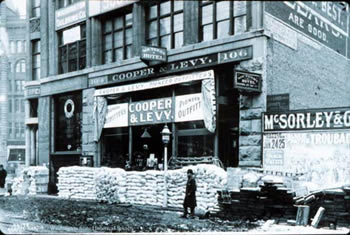 Yukon Outfitters (left). One of the many businesses in Seattle that outfitted the miners for the Yukon. (Special Collections, University of Washington Libraries, Photo by Asahel Curtis, negative #345A.)
The stage was thus set for the city's greatest strokes of fortune, the Klondike Gold Rush of 1897 and the Alaska Gold Rush of 1900 (See also, The Klondike Gold Rush). In the summer of 1896 prospectors found a substantial amount of gold along the Yukon River in Canada; four years later another substantial find was located in Nome, Alaska. These strikes precipitated the last great mineral rushes of the 19th century, and thousands of Americans left quickly for the goldfields. Although the initial strike occurred on Canadian soil, the Canadian cities of Vancouver and Victoria were not well prepared to service it. American cities, on the other hand, began competing earnestly to attract miners on their way to the strikes—most of whom were themselves American and therefore predisposed to depart for the North from an American entrepôt. Now, one may wonder why any city wanted hundreds of mostly young, desperate men passing through it; the big payoff for towns that served as jumping-off points for the Yukon was that miners had to transport all their supplies with them from the lower forty-eight. Seattle, Tacoma, Portland, and San Francisco each wanted to sell those supplies to the miners, and also wanted to be the ports to which miners returned from the north.
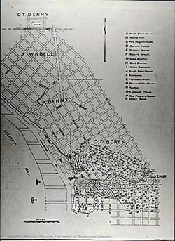 The first plat of Seattle laid out by Arthur Denny, (right). Sketch made by Lieutenant W. S. Phelps of the "Decatur" in c. 1855-56. (Arthur A. Denny, Pioneer Days on Puget Sound. Seattle, 1908. Special Collections, University of Washington, neg. 10049)
Seattle won the struggle to become the most popular jumping-off point to the Klondike, partly because of its proximity to Alaska and its railroad terminus, but also through a massive publicity campaign sponsored by the Chamber of Commerce. A committee led by Erastus Brainerd flooded the nation with advertising that conveyed a simple message: "Seattle is the gateway to Alaska and the Yukon." In Illinois alone, for example, 488 weekly newspapers carried Seattle's promotional message. On October 13, 1897, the Chamber of Commerce sent 212,000 copies of a special 8-page, Klondike edition of the Seattle Post-Intelligencer to post offices and periodicals around the nation. Seattle generated five times as much advertising as any other city on the West Coast, and the advertising paid off. The city received the bulk of the American traffic to the Yukon, and later to other mineral strikes in Alaska, and thus cemented its economic hold over its northern hinterland.
A town was laid out with the help of Arthur Denny, formerly a surveyor in Illinois. He chose the gridiron plan that was the simplest and most familiar format and the one best suited to the buying and selling of property. Nobody cared in the 1850s or 1860s about laying out streets that allowed residences to take advantage of the views from Seattle's hillsides. Rather, people cared about attracting immigrants and investors, and selling land. By 1876 the lands along the 4-mile path from Lake Union to the Duwamish Valley had been platted, ready for sale. However, people resided only within one half-mile of the city center. The town's corps of land speculators had to await the arrival of buyers. Meanwhile, like most other towns on Puget Sound, Seattle got along by cutting and milling lumber and shipping it to markets around the Pacific Rim. Townspeople blamed the "Indian war" of 1855-56 for a slump in growth, but the collapse of the Californian economy—to which Seattle had sent most of its wood—may have been more problematic. In any case, Seattle's growth was too slow to satisfy its boosters.
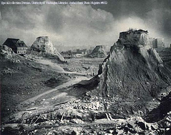 Regrading Seattle, (left): The leveling of the hills to make Seattle. (Special Collections, University of Washington, 1910 photo by Asahel Curtis, neg. 4812)
Seattle had some advantages to help it along. People found coal deposits on the eastern and southern sides of Lake Washington, and by 1871 the city was shipping about 100 tons of coal daily to San Francisco. This gave Seattle a second staple to go along with timber. Still, the city had no more substantial hinterland that it could tap, as Portland was tapping the Willamette Valley and the Columbia and Snake River watersheds. Without access to a "natural" hinterland (i.e. one connected to it by river travel), Seattle hoped for a railroad to connect it to other places. Thus, during the early 1870s when the Northern Pacific Railroad was shopping for a terminus site on Puget Sound (choosing between Mukilteo, Seattle, and Tacoma), Seattleites regarded the matter as urgent and critical. "If we win [the terminus] our property will be quadrupled in value," one newspaper editor explained. "If we lose, it will be depreciated one half to two-thirds. Our destiny must now be settled for years to come." Notice that nobody spoke about developing a satisfactory sense of community, or valuing the natural scenery, or managing growth, or building fine schools, or protecting the neighborhoods, or having just the right kind of coffee merchant on the street corner. The founders thought of Seattle as a gold mine of sorts—not a place to make a life but rather one to make a living, preferably through an increase in property values. This mentality, emphasizing growth at virtually any cost, prevailed in the city well into the 20th century. Seattle was a real estate venture, first and foremost, for its founders. The keys to its success were developing some form of control over the natural wealth of the hinterlands (railroads), and asserting greater control over the landed wealth within the city limits (through efforts to increase property values, commerce, and industry). The city devoted itself to attracting new residents and investors who, it was sure, would help it realize its dreams of greatness.
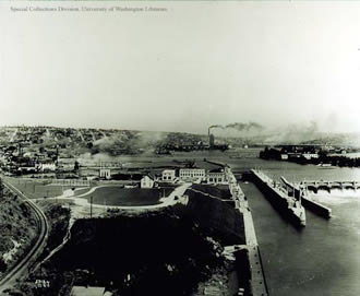 Ship Canal Locks, (right): The Government Locks looking east toward Lake Union. (Special Collections Division, University of Washington, negative 4234)
At the same time, the market created by miners and others headed north stimulated additional enterprises closer to Seattle. Throughout western Washington, farmers and ranchers produced more crops, livestock, and dairy products to sell to the miners and to the ballooning population of Seattle. In other words, Seattle captured not only the rather distant hinterlands of Alaska and the Yukon but also the closer rural hinterlands within its own state. Through the technology of transportation and the workings of the market, it harnessed nature's wealth far more successfully than ever before. The growth that accompanied the Klondike and Alaska gold rushes increased Seattle's population and affluence to new heights.
As the city matured, it sought to make further refinements to itself, thus launching a campaign of civic improvement devoted to mastering nature locally as well. One set of improvements revolved around leveling the steep hills that encircled the downtown. Between 1900 and 1930 the city re-engineered its natural setting by regrading the slopes around the central business district. The hills were seen as an impediment to real estate development; city officials assumed that by lowering the hills they would facilitate the outward growth of the central business district and accelerate the rise in property values. As workmen washed and shoveled and hauled the hills away, they also straightened the lower Duwamish River in order to facilitate shipping on that stream; created Harbor Island, which added to the city's waterfront; and filled in some of the tideflats in the area just south of Pioneer Square (the spot occupied by the Kingdome between 1976 and 1999).
Furthermore, in 1916 the city, assisted by the U.S. Army Corps of Engineers, completed the Seattle Ship Canal which, with the help of a system of locks, permitted ships to travel from Puget Sound through Lake Union into Lake Washington. One goal of the canal was to permit the industrialization of Lake Washington by making it more accessible to ocean-going vessels. It should be noted that each of these projects had enormous environmental consequences, few of which were given much thought at the time. For example, water and anadromous fish used to drain out of Lake Washington at its southern end, into the Black and then the Cedar and then the Duwamish rivers on their way to Elliott Bay. After 1916 the lake was lowered by about ten feet, and it now drained out to the Sound primarily via the ship canal. Salmon had to struggle to and from the sea through the locks and the accompanying fish ladder. We have only recently grasped the great consequences of such ecological changes.
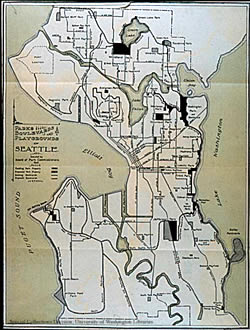
Map of the Olmsted Brothers' park and boulevard system for Seattle, (left). ("Parks, Boulevards and Playgrounds of Seattle," Issued by the Board of Parks Commissioners. Special Collections, University of Washington, F899/S4/S235)
Most of the harnessing of nature that Seattle undertook during the early 20th century was meant to increase its economy and expand its population. The ethos of growth, implanted by the founders, still governed the city. At the same time, there emerged a new interest in aesthetic refinements. The rising population and expanding streetcar system encouraged the population to build new residential districts that took advantage of the city's natural amenities. Homeowners began to value and appreciate the many views of water and mountains that the city possessed. As people moved away from the city center, it should be noted, they also created a more segregated city, for classes and races that had mixed together before were now increasingly separated. Another urban "improvement" was the development of the city's park system. In 1903 Seattle hired the Olmsted Brothers, of Brookline, Massachusetts, to lay out a park system for the city. John C. Olmsted, the landscape architect who planned for new parks and parkways, was struck by the natural vistas that Seattle offered. The city would never need a huge green space like New York City's Central Park, he concluded, because its residents would always have access to views of forests and mountains, of lakes and Puget Sound. People expressed a growing appreciation for the mixture of urban and natural amenities that Seattle promised. It was around this time, too, that residents of Seattle and Tacoma began making the newly established Mount Rainier National Park part of their collective backyards. Parks of all kinds were another way of mastering nature while at the same time appreciating it.
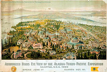
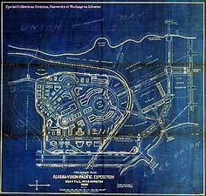
The "authorized birds eye view of the Alaska-Yukon-Pacific Exposition" compiled by William Caughey in 1909. (Seattle, 1909. Special Collections, University of Washington)
In 1909 the city of Seattle celebrated its prodigious growth and recent civic refinements by hosting a world's fair, the Alaska-Yukon-Pacific Exposition. The fair meant many things to the city. It announced Seattle's maturity, the passing of its "frontier" stage and its arrival as a major American city capable of hosting an international exposition. (The fact that Seattle's key rival, Portland, had hosted its own world's fair in 1905 naturally spurred the people of Seattle to do what they could to match and then surpass that event.) It suggested that Seattle had become refined enough to bring together in one place civilization's finest products of science, art, and industry. The fair, promoters claimed, was "wisdom personified." That it took place on the campus of the University of Washington doubtless gave this claim added credibility. (What the University got from the fair, of course, was more concrete—many new buildings and a new campus plan, laid out by John C. Olmsted and coordinated—at least briefly, in Olmsted's thinking, with the park system.)
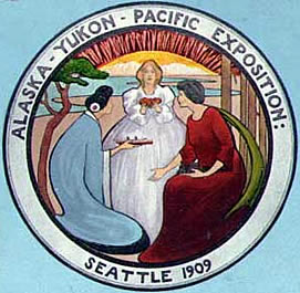
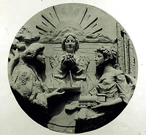
But the fair had a more materialistic rationale as well. Seattle leaders meant not only to celebrate recent growth but also to promote additional growth, to advertise the city and attract new immigrants and investors. The A-Y-P aimed—like Klondike-era publicity had before it—to convince Americans that Seattle was the nation's doorway to trading around the Pacific Rim. One booster explained, "Seattle has assumed the task of introducing the half of the world which is developed almost to the ultimate [the U.S.], to that other half [Alaska and East Asia] which to all intents and purposes of trade, is developed not at all." Note the name of this fair in particular, which commemorated not the host city but rather the city's economic hinterlands—Alaska, the Yukon, and trading partners in Asia. In almost every respect, the exposition stressed the accomplishments and refinements of Seattle, and juxtaposed them to the natural wealth of the city's less refined hinterlands. The official seal (below, far right) illustrated Seattle's aspirations. The figure on the right represented the forested American Northwest, ready to serve commerce via rail connections; the figure on the left represented Japan and Asia, linked across the ocean by steamship; the figure in the center, beneath the northern lights, represented Alaska and her untapped wealth. Alaska stood as a meeting ground for East and West, and would "supply the wealth for both." A little more harnessing of nature—by rail or by sea, or by one of the many mechanical inventions featured at the world's fair—seemed to be all that would be required.
Map of University of Washington campus (above). (Courtesy of Special Collections, University of Washington)
Alaska-Yukon-Pacific Exposition Insignia Alaska-Yukon-Pacific Exposition seal, (left). Official design. (Special Collections Division, University of Washington Libraries, Photo by F. H. Nowell, official photographer of the AYP. Nowell negative #236; UW negative #236.) Alaska-Yukon-Pacific Exposition seal, (right). Official design in staff. (Special Collections, University of Washington Libraries, Photo by F. H. Nowell, official photographer of the AYP, 1909. Nowell negative #90.) |
 |
|
| Course Home | Previous Lesson | Next Lesson |