Lesson Ten: Lines on the Land
When the first American fur traders and settlers saw the Willamette Valley, they wrote glowingly about its natural beauty and its suitability for farming. It seemed to them as if nature had made the valley for the explicit purpose of planting crops, grazing livestock, and pleasing the eye of overland migrants from the east. Much less obvious to pioneers was the fact that Indians had very consciously shaped this environment through fire. Annual, low-intensity, controlled burns, set in the late summer, had minimized the valley's underbrush, reduced the number of trees, facilitated native hunting and gathering, and created the prairie-like appearance that settlers so appreciated. The Willamette Valley was in substantial part the artifice of Indians and of fires set by Indians.
Once American settlers set up homes in the area, however, their first impulse was to suppress the fires that Indians set. From the viewpoint of the farmer, rancher, and homeowner, fires—whether caused by Indians or not—were a wild force of nature that threatened the crops, livestock, and buildings that settlers had brought with them to Oregon. Or, more to the point, they threatened to destroy the value of the property that settlers had brought to and created on the land. Thus Jesse A. Applegate, a very early settler, recalled the frightening effect of such a fire:
We did not yet know that the Indians were wont to baptise the whole country with fire at the close of every summer; but very soon we were to learn our first lesson. This season [1844] the fire was started somewhere on the south Yamhill [River], and came sweeping up through the Salt Creek gap. The sea breeze being quite strong that evening, the flames leaped over the creek and came down upon us like an army with banners. All our skill and perseverance were required to save our camp. The flames swept by on both sides of the grove; then quickly closing ranks, made a clean sweep of all the country south and east of us....The Indians continued to burn the grass every season, until the country was somewhat settled up and the whites prevented them.
(Joseph Schafer, ed., A Day with the Cow Column in 1843. By Jesse Applegate. Recollections of My Boyhood. By Jesse A. Applegate [Chicago: Caxton Club, 1934], 137-38. Applegate is cited in the discussion of fire by Robert Bunting, The Pacific Rain coast: Environment and Culture in an American Eden, 1778-1900 [Lawrence: University Press of Kansas, 1997], 12-15, 80-85.
Although most settlers did not realize it, fire had been one of the things that made the Willamette Valley an appealing destination for them. However, as soon as they established homes and farms and ranches and businesses in the area, settlers prevented Indians from setting their annual fires. For Indians, fire was a tool that enriched their habitat in numerous ways. For non-Indians—who fixed themselves upon the land with fields and fences and farmhouses, rather than moving across it seasonally—fire represented a threat that needed to be extinguished. That is, in the Indians' hands, fires threatened because they seemed to be "wild" and out of control. These different attitudes toward fire, then, mirrored different attitudes toward the land and its uses, as well as different conceptions about "wild" and about property.
 That Indians used fire to modify nature reminds us that the land was not "pristine" or free from human influence before settlers arrived. Nonetheless, settlers immediately sought to transform the land by manipulating it so that it resembled the landscapes they had known back east. It is true that settlers were changed at least somewhat by the western lands to which they migrated; but it is even more important to see that those settlers were bent upon changing the lands they encountered in order to make them conform more closely to the places from which they had come. Westering migrants did not so much create new societies and institutions in the West as to transplant societies and institutions from the East to the West. The Willamette Valley and Puget Sound countries attracted their eye, but both areas needed to be reshaped in the eastern image before they could be deemed comfortable and productive places to live. In short, in colonizing the land and other natural resources, newcomers began to modify them in much more intrusive and heavy-handed ways than Indians had. And, the colonizers also began to deplete the Northwest's resources in ways the Indians had never really been capable of.
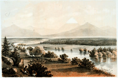
Above right: An example of southern Oregon meadows created by Native American Burning. Henry Abbot, of the U.S. Railroad Survey "credits Indians with excavating water holes and firing the landscape to foster the growth of grass for their horses," as shown here along the Klamath River and Upper Klamath Lake in Southern Oregon. Reports of Explorations and Surveys, Washington, D.C., 1857. Plate IV, Vol. 6, facing p.69. Caption citation: William G. Robbins, "Landscape and Environment: Ecological Change in the Intermontane Northwest," Pacific Northwest Quarterly, Vol. 84:4, p.145.
Successful colonization of the Pacific Northwest required that its lands be integrated into the political, economic, and cultural systems of societies headquartered back east. This integration in turn entailed a virtually endless process of drawing lines on the land. Explorers had begun this process by mapping and charting and claiming territory in the region, and devising routes to it. The "noble science of discovery," to use George Vancouver's words, integrated the Northwest into Europeans' and Americans' conceptual worlds by describing and naming the country so that it seemed familiar, and placing it into an accepted framework of latitude and longitude. The Northwest had to be colonized intellectually before it could be colonized in other ways. Fur traders, including the Hudson's Bay Company, continued the process of integration by linking the Pacific Northwest to global markets in commodities and global routes of transportation and by strengthening national claims to the territory. With each linkage or line drawn, the country came into clearer relief.
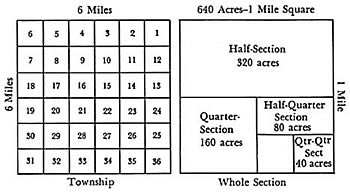
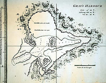
Standard Section Divisions--how every section in the West is divided, left. Both towns and farms conformed to the federal survey grid. In some instances, even rivers and streams were reshaped to fit the lines on the land. Reproduced in Everett Dick, The Lure of the Land: A Social History of the Public Lands from the Articles of Confederation to the New Deal (Lincoln, 1970), following p.178. Grays Harbor, below. George Vancouver, A Voyage of Discovery to the North Pacific Ocean (London, 1801,) chart #11.
The international boundary settlement of 1846 drew still another line on the land—the border between British North America (later, Canada) and the United States. (This line on the land was a complete anomaly to the Indians whose homelands straddled the 49th parallel, of course.) By finalizing the division of territory between Britain and the U.S., the international boundary facilitated the drawing of additional lines. On the American side of the border, settlers in the early 1840s had organized a "provisional government" in order to create a familiar, secure, predictable American framework for settling Oregon. Now that the region was officially part of the United States, they anticipated the drawing of lines that would indicate the presence of a not-so-provisional government. For example, following a well-established American system, the federal government drew and redrew a series of lines to create the territories of Oregon (1848), Washington (1853), and Idaho (1863), and the state of Oregon (1859). (For a map of these shifting lines, see Schwantes, p. 254.) These lines represented the integration of the Pacific Northwest into the U.S. political system. Integration did not come immediately, but residents were assured that for purposes of government and law that they now fell within the orbit of American (rather than British or native) ways, which included some measure of self-government. Territories and states, of course, quickly set about drawing additional lines in order to create counties, capitals and other towns, and additional governmental and political units. In other words, they subdivided themselves in the American way.)
The integration of Oregon and Washington into the United States after 1846 ensured that settlers' claims would be recognized and incorporated into the American economic system, one in which the federal government, by drawing additional lines upon the land, fulfilled its responsibility for creating land title in western territories. In 1850 Congress passed the Donation Land Claim Act, which not only legitimized most of the claims of pioneers who had settled in Oregon prior to 1846, but also offered new arrivals the chance to acquire their own parcels of land (see Schwantes, p. 121). And at a time when the government was selling land to settlers elsewhere, this act authorized the government to give land away, or donate it, to settlers in the Pacific Northwest. Federal officials were further charged with the responsibility for surveying the lands of the Northwest and making them available to claimants and buyers. By platting the territory the standard grid pattern and arranging for the transfer of this public property into private hands, the government exerted a profound influence on the economy of the region. (Most of the land surveyed by the U.S. was not claimed by private citizens, and thus remained in the hands of the federal government. By the 20th century, this sizable unclaimed territory had become a welter of national parks and national forests, military bases and nuclear sites, interstate highways, Bureau of Land Management acreage, dam sites, wild and scenic rivers, and Indian reservations, among other things—as well as a constant source of tension between the states and the U.S. government. The states also acquired title to their own share of the public lands, and so did some local governments.)
By drawing lines upon the land, federal officials created parcels of property that could be bought and sold and taxed and leased and bequeathed to heirs. In other words, government legitimated the landed basis for the regional economy. Private owners and state and local governments then drew additional lines on the lands that they controlled. Towns built roads that carved communities up into grids, for example, while property owners subdivided their parcels by drawing new lines, and often reinforced those lines by building fences, planting hedges, or erecting buildings. All of these modifications, of course, represented drastic departures from how native peoples had treated the same territory. Indeed, they symbolized a dramatically different way of looking at and relating to the lands of the region—a way shaped by both American and international versions of such forces as market capitalism and Christianity.
The transformation of Northwest lands at the hands of American colonizers entailed two other powerful sets of changes as well. One was biological. We have already considered how Europeans introduced epidemic diseases to natives of the Northwest. (In the Willamette Valley, one effect of these diseases, especially the malaria epidemic of 1830-33, was the virtual depopulation of the valley. Another attraction of the area was the relative absence of natives to resist settler designs on the area.) In addition to introducing deadly diseases to Indians, the newcomers also brought with them a host of plants and animals that had never been part of the regional ecosystem before. Cattle and horses and wheat and potatoes were all part of the familiar eastern worlds that westering migrants wanted to transplant to the Pacific coast. But these exotic species could not simply coexist easily with indigenous species. The spread of settlers' crops and livestock, along with a host of other environmental changes—the arrival of new kinds of weeds; the outbreak of disease; the suppression of Indian fires—drastically altered native ecosystems.
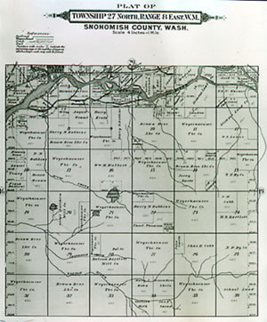
Plat of Township 27 North, Range 8 East W. M., Snohomish County, above. (Special Collections, University of Washington)
One example of these changes occurred on Whidbey Island in Puget Sound. The island's ecology had already begun to change before settlers showed up to claim land during the 1850s. Indians there had acquired such things as blankets, guns, and potatoes from fur traders, which had changed subsistence patterns: they relied less on hair from domesticated dogs to produce blankets; their new ability to hunt with guns depleted game more rapidly; and potatoes partially replaced camas roots in their diet. But the settlers who arrived to farm and raise livestock transformed the ecology even more forcefully. They divided the land into parcels of private property, and marked off roads for transportation (unintentionally clearing a pathway by which exotic species of weeds spread rapidly to their fields). They introduced wheat, oats, and other crops, while trying to discourage the growth of the bracken plants on which Indians had relied. They plowed land for the first time (which soon reduced the fertility of the soil). They also introduced hogs and cattle, and at the same time exterminated wolves from the island to protect their stock. Within a short time, the ecosystem was utterly different from what it had been. One farmer eloquently explained that the goal behind these changes was "to get the land subdued and the wilde nature out of it. When that is accomplished we can increase our crops to a very large amount and the high prices of every thing that is raised heare will make the cultivation of the soil a very profitable business" (cited in Richard White, Land Use, Environment, and Social Change: The Shaping of Island County, Washington [Seattle: University of Washington Press, 1980]).
Settlers thus remodeled the landscape—in this case and most others by remaking it not only for economic use but also for the purpose of creating a place that seemed familiar rather than "wilde" and strange. They inscribed a new set of lines on the land that linked it directly to the larger society of 19th-century America, one defined in substantial part by market capitalism and the individual pursuit of gain. Another powerful set of lines drawn by settlers upon the land of the Northwest were social boundaries that prescribed where groups of people could or could not reside. The people who moved to the Pacific Northwest brought to the region all the diversity of the American population, so that European immigrants and African Americans and Latinos and natives from east of the Rocky Mountains, for example, were all part of the newly arrived populace. Yet they also brought the prejudices and racism of the eastern states to the region. In the same way that the newcomers strove to replicate the natural environs they had left behind, so they tried to reproduce their social environs and, if possible, "improve" upon those they had left behind. Their efforts ensured that groups of people who were marginalized back east would remain marginalized in the Northwest.
George Washington Bush (right), who became Washington's first African American settler when he came to the Tumwater area in 1845. Even so, it required a special act of Congress to allow him to obtain the deed to his homestead. (Drawing by Samuel Patrick for the Los Angeles Times, courtesy of the Henderson House Museum, Tumwater, Washington.)
Treatment of African Americans in Oregon exemplified what could happen. In 1844 the provisional government prohibited African Americans, both free and slave, from entering and living in Oregon. This effort was not unusual at the time; most new states and territories were populated by migrants who hated blacks as well as slavery and wanted to eliminate one or both of them from their new places of residence. White settlers in early Oregon in 1844 acted to outlaw blacks after two episodes led them to think that African Americans were likely to provoke or even encourage Indians to attack the new settlements. (See Thomas C. McClintock, "James Saules, Peter Burnett, and the Oregon Black Exclusion Law of June 1844," Pacific Northwest Quarterly 86 [Summer 1995]: 121-30.) In 1849 the legislature of Oregon Territory continued the exclusion of African Americans; when Oregonians voted on a new constitution, prior to becoming a state in 1859, they voted by eight-to-one to prolong the exclusion. Although not rigidly enforced, the exclusion law remained on the books until the 1920s. Of course, the most lasting lines meant to divide peoples within the region were those intended to segregate native peoples on reservations. These lines, and their consequences, are the topic of the next lessons.
To colonize the Pacific Northwest, arriving settlers drew all kinds of lines on the land—lines to link the region to life back east; lines to subdivide the region; lines to include and exclude groups of people. These lines brought the region into the social, political, economic, and biological framework of the eastern United States, and thereby made it a much more thoroughly American region than it had ever been before.
In drawing new lines on the land, arriving settlers were very consciously trying to remake the Northwest into a place that either resembled or improved upon the places they had left behind. They were purposefully reshaping the region in order to make it more familiar and malleable to their designs. Yet their reshaping had many unintended consequences, for settlers could fully control neither the tools they brought to this remodeling project nor the nature that they hoped to tame. Their management of fire exemplifies the problem. Settlers used fire intentionally to clear land, fell trees, heat their homes, and accomplish other tasks. By suppressing the Indians' annual burns in the Willamette Valley, however, settlers unintentionally reduced the amount of prairie-like land, increased the amount of forest land, and probably heightened their vulnerability to invasions of grasshoppers. Their mastery of nature in the Northwest was always quite limited.
Over the course of the 20th century, farmers in the valley reintroduced the practice of setting fires at the end of every summer. Growers of grass-seed crops—approximately 300,000 acres' worth by the 1960s—burned their fields after every harvest in order to kill fungus and clear the way for the next year's crop. These fires sometimes got out of control, so much so that nearby residents protested and tried in vain to prohibit them. In August of 1988 one such fire spread beyond the fields for which it was intended. The smoke engulfed the nearby freeway and caused one of the worst automobile accidents in the state's history. Twenty-three cars were involved, seven people died, and thirty-seven more were injured. (Peter G. Boag, "The World Fire Created: Field Burning in the Willamette Valley," Columbia 5 [Summer 1991]: 5-11.)
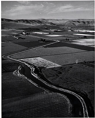
An eastern Washington farm landscape. (Special Collections, University of Washington, Agricultural Files. Photo by Fred Milkie, Seattle, Washington, UW negative #438.)
| Course Home | Previous Lesson | Next Lesson |