The Challis Episode:
Turmoil in the Columbia Embayment
57-37 million years ago (Eocene Time)
|
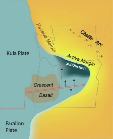
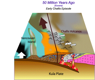
The Challis Episode, named after a small town in Idaho, is the most controversial chapter in the geologic history of the Pacific Northwest. Large regions of the Pacific Northwest were folded, faulted and rearranged, all the while hosting a chain of volcanoes running diagonally across Washington and Idaho. At the end of this period, a large piece of ocean floor (now the Olympic Peninsula) was uplifted and forced beneath the edge of the continent, extending the continental margin to its modern western limit. This development was symptomatic of a more profound change, which would evolve over the next ten million years, that being the ultimate demise of the Kula Plate. Over this period, the ridge between the Kula Plate and the Farallon Plate to the south appears to have slowly moved northward up the coast, eventually fragmenting into pieces as the Farallon Plate exercised its dominance. On the south side of that division, the Farallon Plate began subducting underneath the continent, giving rise to the modern Cascade Arc regime. This regime slowly moved northward up the coast behind the decaying Kula-Farallon transform, reaching into modern-day Washington by about 37 million years ago. In this respect, the Challis episode is a transition between the more extensive Coast Range and Cascade Arc Episodes. The Challis Episode is the most complex and enigmatic of the major chapters in regional geologic evolution, including a variety of interrelated aspects. These include the tectonic relationships accompanying the breakup of the Kula Plate, two distinct concurrent episodes of volcanism, and a widespread depositional component that left much of the region thickly blanketed in sediment. The course of events over this period remains a subject of considerable debate. For now, all we can offer is our "best guess" of events that happened in the Columbia Embayment that created geologic havoc over much of Washington.  A Tectonic Revolt in the Columbia Embayment As the Farallon Plate advanced northward into the Columbia Embayment, it appears that the Kula Plate broke into several north-south trending blocks separated by transform (strike-slip) faults in the oceanic lithosphere. One of these developed at about 121o30â longitude, dividing the plate into two halves within the Columbia Embayment. Each of these blocks underwent a different course of evolution. |
|
The eastern block of the Kula Plate was continuously subducted to the north underneath the southern exposure of the accreted terrane belts between 57 and 40 million years ago. In a broad swath extending from southwest British Columbia into central Idaho, this gave rise to a volcanic arc known as the "Challis Arc". The Challis Arc, which lends the Challis Episode it name, was responsible for a chain of volcanoes on the surface and a suite of granite-type rocks intruded at depth. The western block of the Kula Plate had a very different history. Between 57 and 50 million years ago, this block maintained a passive margin with the continent to the north. Instead of producing new ocean crust and propelling that section of the Kula Plate, vast quantities of molten basalt were erupted on the ocean floor. These basalts, known as the Crescent Basalt, accumulated to great thickness until plate motion finally resumed at about 50 million years ago. The Crescent Basalt makes up the core of the Olympic Peninsula today. |
As the spreading center between the Farallon and Kula Plates moved into the Columbia Embayment, the Kula Plate began fragmenting into two distinct blocks separated by a transform fault. The eastern block subducted along the southern margin of Washington along an active continental margin. The western block, however, expended its energy by erupting thick basalt along the spreading ridge. To the north of this block, Washington enjoyed a quiet, passive continental marginâ¦at least for a time. |
The Western Block Breaks Free
|
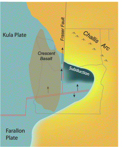
When the western block started moving north again at about 50 million years ago, it did so not by subducting underneath the southern edge of the embayment, but by fracturing the western edge of the continent in a crustal-scale north-south trending fault that extends some 500 miles north into northern Canada. This fault is called the Fraser Fault, or locally as the Straight Creek Fault. Between 50 and 40 million years ago, the block on the west side of the fault was moved northward by some 90 miles relative to the east side, displacing once-continuous belts of accreted terranes. As if Washingtonâs geology was not already complex enough! In the final stages of movement on that fault, the passive margin between the western block and Vancouver Island finally ruptured. The ocean plate, carrying the Crescent Basalt on top, dove partially under the margin. In doing so, it accreted this fragment of ocean plate to the edge of the continent, where it is now the Olympic Peninsula and associated rocks to the south. This was the final element in the Pacific Northwest "collage" of terranes. |
The western Kula Plate breaks free. The transform boundary between the eastern and western blocks of the Kula Plate finally penetrated the continental margin of Washington and British Columbia. As it did, the western block of the Kula plate and the southwest margin of Washington moved about 90 miles north between 50 and 40 million years ago. The Crescent Basalt also moved northward toward its present position in the Olympic Mountains region. |
|
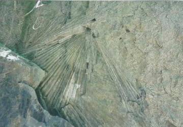
Core Complexes of the Okanogan Region Granitic plutons of the Challis Arc outcrop in the North Cascades, in the Okanogan Highlands, and presumably are preserved at depth in a belt extending southeast into south-central Idaho. In the Okanogan region, the intrusion of granitic molten rocks produced a unique development called a âcore complexâ. Molten plutons of the Challis Arc intruded to shallow depths underneath older plutons of the Omenica Arc. As the hot new Challis plutons contacted the old, cold Omineca plutons, the older plutons were raised slightly and their bases softened. Along that soft, ductile boundary, the upper rocks then slowly slid off the rising plutons, driven by gravity. |
Mylonite â extremely stretched granitic rocks â slid off the top of a core complex to form these steeply dipping âflat ironsâ in the Riverside, Washington area. Photograph by Eric Cheney |
|
The product of this process is a "core complex." The core complexes of the Intermontane Belt are excellent examples of these phenomena. At the ductile boundary along which the upper plate slid off the lower plate, the granitic rocks stretched out to extreme degrees, forming a rock known as a "mylonite". The mylonite rocks in the Tonasket region are world-renown examples of this unique type of rock. |
|
Washington is Buried in Sediment The most extensive products of the Challis Episode were vast blankets of sediment deposited (mostly sand and silt) along the margin of the continent. These are some of the thickest non-marine sedimentary formations in North America. At the dawn of the Challis Episode, most of what is now Washington State was a broad coastal floodplain. The site of the modern North Cascades Range was at very best a low set of hills. The southern shoreline was probably not far south of modern-day Seattle, with a western shoreline not too far west of the modern-day Puget Sound. Across this landscape, very large river systems drained to the southwest, emptying into the Columbia Embayment and the Pacific Ocean. Draining the interior provinces of Canada and the highlands of northern Idaho, these rivers carried vast amounts of sediment (mostly sand and silt) toward the ocean. As they wound their way through the coastal lowlands, they deposited a great thickness of sediment that eventually hardened into layers of sandstone. In places, these river sediments accumulated to nearly 3 miles in thickness |
|
Sandstone and siltstone from the Challis Episode are still widespread some 40 million years later. Sandstones on the east side of the Cascades between Cle Elum and Leavenworth, those in the Republic area in the Okanogan Region, those of the Chuckanut Formation in Bellingham, the Renton and Tukwilla formations around Seattle, and the Lincoln Creek and Cowlitz Formations in the Centralia area are all from this episode. An abundant fossil record from these formations paints a picture of a warm, moist, and nearly tropical coastline setting. Among the most common of fossils from this period are fronds from palm trees. These sediments probably started accumulating about 55 million years ago, and continued to accumulate through perhaps 40 million years ago. Among the earlier of these were the deposits of the Swauk Formation around Cle Elum and the Chuckanut Formation around Bellingham. These two formations accumulated in a common basin between 55 and 50 million years ago. They were subsequently offset by about 90 miles along the Straight Creek Fault between 50 and 40 million years ago. |
Fronds from ancient palm trees preserved in the Chuckanut Sandstone near Bellingham.
One of the thickest blankets of nonmarine sediment in North America accumulated along the passive margin of Washington during the Challis Episode (in the region shown in orange). When the western block of the Kula Plate broke free, the old continental margin moved northward about 90 miles along the Straight Creek Fault. |
|
The End of the Challis Episode The Challis Episode ended as the last remnants of the Kula Plate subducted underneath the eastern half of the state, as the Crescent Formation was thrust underneath Vancouver Island on the western side of the state, and as the last of the Kula Plate to the west finally yielded to the advances of the Farallon Plate to the south. The developments put an end to the Challis Arc and an end to movement on the Straight Creek-Fraser Fault by about 40 million years ago, in Late Eocene time. With the close of the Challis Episode, the final piece of the Pacific Northwest "collage" - the Olympic Peninsula and kindred rocks to the south - was finally emplaced in the continental margin. As this was completed and the Kula Plate faded into history and the Farallon Plate resumed its reign along the North American margin off the Washington and southern British Columbia coasts. As it did, the region moved into the next and final chapter in its evolution, the Cascade Episode. |
Continue to:
§ The Cascade Episode (37 million years to present)
Return to:
§ Northwest Origins Home Page
§ Dance of the Giant Continents
§ New Lands along the Old Coast
