April 1, 2010
PhotoCity, virtual capture-the-flag, starting this week on UW campus
It’s an intercollegiate challenge that’s a little bit different. No balls, sticks or stadiums are involved. Any number of people can participate. The playing field is the entire campus. And the only equipment you need is a digital camera.
The goal is to capture the campus, one photo at a time.
Through April 20, anybody is invited to snap digital photos of the University of Washington campus in a game of virtual capture-the-flag. Students, faculty, staff and community members are all invited to participate.
To play, go to http://photocitygame.com to sign up. There you’ll find a campus map showing white flags that have yet to be captured, as well as colored flags that have already been claimed by one of four teams. Go here to learn more about the competition.
Next take your camera or other device and snap photos at the flag’s location. You can submit photos instantly using the game’s iPhone application or upload photos to the game’s Web site. Points are awarded for the number of photos, the resolution and quality of the images and, most importantly, whether a player was the first to capture a flag.
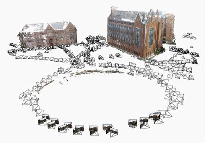
The game, PhotoCity, is a project by computer scientists looking at ways to make 3-D models of neighborhoods or cities. Reconstructions have been started at the UW and Cornell campuses, New York City, San Francisco and Seattle. The game is being organized by researchers who are using their own campuses to test a new strategy to acquire images for their models.
“Our main goal is to get a giant 3-D reconstruction of the entire UW and Cornell campuses,” said Kathleen Tuite, a doctoral student in computer science and engineering. “For players, you’re adding geometry to a model and you’re creating a building out of nothing. You’re also gaining points, capturing flags and getting fame and glory for your team.”
If this first public test of PhotoCity is successful, it could provide a model to encourage residents to work together to acquire photos for digital reconstructions of neighborhoods or entire cities.
Zoran Popovic, an associate professor of computer science and engineering, is leading the project at the UW.
“Our lab is working on computer games that solve really hard problems,” Popovic said. “In this case, it’s unusual compared to most computer games in that this has people going out into the real world instead of sitting in front of a computer. It’s not really known how addictive or how exciting it’s going to be, but it’s really a way to acquire data in a way that would not be possible any other way.”
The UW team is working with collaborators at Cornell University led by Noah Snavely, a graduate of the UW’s computer science department and now an assistant professor of computer science at Cornell. Snavely’s doctoral research at the UW created Photo Tourism, a tool that combines photos posted on the photo-sharing Web site, Flickr, to create 3-D models. That technology is licensed to Microsoft as the basis for the free tool Photosynth.
Researchers at UW and Cornell have been working together to push Photo Tourism’s limits, to create higher resolution and city-scale models. But relying on tourist photos meant that gaps remained in places that were less photogenic.
They hope that PhotoCity, a research project funded by Intel, may help fill those gaps.
“There are people walking around with cameras all the time, and if just a small percent of them took helpful pictures of buildings from the right angles, then we could potentially build up a 3-D model of a city in a very fast, cost-effective and hopefully fun way,” Snavely said.
Players will get to compete individually, on teams at each campus and between campuses.
“We’re hoping to publish a paper on the effectiveness of PhotoCity as a way to create a 3-D replica of the entire urban world,” Popovic said.


