February 18, 2010
UW is home to network that keeps an eye on lightning around the world
What do you do if you are a scientist who studies space physics and electromagnetic properties of the atmosphere and a powerful force — namely, lightning — interferes with your work? If you are Robert Holzworth, you study the interference.
“I got involved with thunderstorms and lightning because it was a noise source for my research, and it turned out to be really interesting,” Holzworth said.
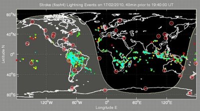
From his office and laboratory in Johnson Hall, the UW Earth and space sciences professor manages the improbable-sounding World Wide Lightning Location Network. With about 50 sensors currently in place, the network picks up an average of about five lightning strokes per second, or 12 million to 13 million a month, from around the globe.
“We don’t see all the lightning. We only see 10 to 30 percent,” Holzworth said. “But we see half of the big stuff, the strokes with the most interesting effects.”
Holzworth’s primary research involves Earth’s magnetic field and properties of the ionosphere, the uppermost part of the atmosphere that starts at about 45 miles in altitude. He gathers data using satellite sensors that peer down at the ionosphere and devices that look upwards from balloons flying at about 22 miles high.
The ionized gas of the ionosphere is key to bouncing radio signals over long distances. Radar is the primary means of seeing what is happening in the ionosphere, but the ionosphere also is instrumental in allowing radar to detect some sorts of human activities — missile launches, for example — at great distances. But the powerful force unleashed by a lightning stroke can interfere with radar’s ability to gather accurate data from a specific level within the ionosphere.
“Sometimes you get a nice steady picture and then, boom, lightning, and you get reflections from different altitudes,” Holzworth said.
The idea of a global lightning location network was patented in 2003 by Richard Dowden of the University of Otago in Dunedin, New Zealand, who was named a fellow of the American Geophysical Union because of his pioneering work on the network. Holzworth took over in 2004 when Dowden retired, though the University of Otago remains a key location for the network, with a computer station fully redundant to the UW operation.
Gamma rays, high frequency electromagnetic radiation that can cause tissue damage, are detected by satellites when they originate in other star systems. But it turns out there also are gamma flashes from Earth, though scientists are still trying to understand them. The lightning location network has been instrumental in correlating some gamma flashes with lightning.
The network also is providing useful data that can help scientists understand how hurricanes begin, develop over time and end, Holzworth said. Positively and negatively charged particles in close proximity to each other can be swept apart by the roiling storm, providing conditions for larger lightning flashes as the charge travels between positive and negative particles. The lightning strokes allow scientists to see what is going on within the storm.
For example, UW atmospheric sciences researchers in 2005 investigated the notorious Hurricanes Katrina and Rita and found that Rita intensified rapidly from the least-intense category 1 to the most-intense category 5 in less than a day, then suddenly lost intensity again. An important aspect of such intensity changes is the formation of a new wall of clouds surrounding the hurricane’s eye that moves inward and replaces the old eyewall, a process documented by the UW team.
“Eyewall replacement is illuminated in lightning much of the time, and we often can identify when that is happening,” Holzworth said.
Some lightning location network data is available on the Internet (http://wwlln.net), but the network also sells data in minute-to-minute feeds for commercial use. Some airlines, for example, subscribe to the near-real-time feeds to plan flight routes. Data sales currently bring in more than $130,000 a year and provide more than half the network’s annual funding.
All of the sensors are hosted by governments or universities, which provide the hardware and the Internet connection to transmit information. In return, they share all the network’s data. Holzworth said there are places, such as northern Russia and Africa, where he would like to see more sensors, and eventually he’d like to have them spaced about every 1,900 miles. As it is, they are close enough for the network’s requirement that at least five stations must sense a lightning stroke to provide a precise location.
“At night there’s no place on Earth that can’t be seen by 11 of our sensors, at a minimum,” Holzworth said. “During the day, that drops off to our minimum of five.”
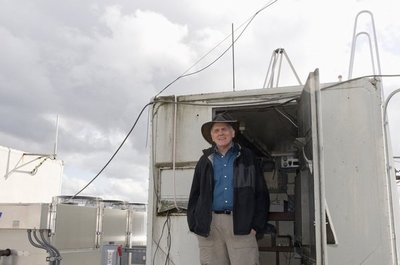
One of those stations sits atop the Atmospheric Sciences/Geophysics Building on campus. An unassuming rod that extends a few feet above the roof is wired a few feet away to a trailer that houses an array of computers. Even though lightning is much less common in the Seattle area than in other parts of the world, the UW station still collects its share of information.
“Lightning is one of nature’s most-powerful phenomena,” Holzworth said. “That’s why we can see it here.”


