November 12, 2009
Explore beautiful old world, regional maps in new UW Libraries digital collection
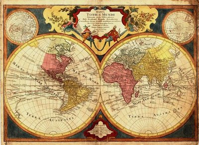
You can trace humankind’s exploration of the world in the maps created over the centuries. And now you can be the explorer, examining regional and world maps — really, really up close — in UW Libraries Special Collections’ newest digital collection, World and Regional Maps Collection, 16th to 19th Centuries.
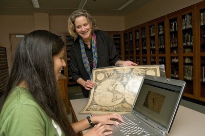
The project was organized by Kris Kinsey, digital projects coordinator for Special Collections, and staff researcher Sammy Franklin, a recent graduate of the Master of Library and Information Sciences program. It took about a year, and the two are justifiably proud of their work.
Kinsey, a longtime UW Libraries employee, said she’s been interested in sharing “these incredible resources” for many years. “I always wanted to work with them and the idea of digitizing them and making them available … was a fascinating project. It was kind of the final end for all the research that we had done through all those years.”
Kinsey hired recent graduate Franklin to do the legwork, research and cataloging for the project. “Sammy just took the bull by the horns and went for the research end of it,” Kinsey said. “She was really incredible — I just don’t think we could have done this without her.”
Franklin, who will shortly leave the UW for other work, said, “It was a nice project because it gave me a chance to look at a body of material and decide how best to organize it.” She added, “From a project management perspective and from an information perspective, this was a really good experience.”
There are 178 maps in the new digital collection, dating back to the 1500s and depicting the known world, hemispheres, continents, countries and cities. You can search the collection by century, by area, by cartographer and other criteria.
The digitalized maps represent just a fraction of the UW’s total holdings in maps, Kinsey said; the Map Division of UW Libraries has a huge collection of more recent regional and world maps. And she said there is another digital collection devoted more exclusively to Northwest maps that was created in cooperation with Washington State University.
Kinsey said UW Libraries takes the digitizing process quite seriously. She used a bar scanner at Facilities Services to scan the large maps to produce large-format TIFF scans that allow for such rich details to be explored. “We use very high security” for the cherished old maps, she said. “I walk them over there myself.” After scanning, she said they adjusted and edited them some in Photoshop.
The maps are fascinating both in their relative accuracy, given the methods of the time, and for how they depict areas not yet explored when they were made. Early mapmakers often indulged in cartographic fantasies such as mermaids, sea monsters and mythical kingdoms to populate yet-unknown areas, and such imagery recedes in the light of new exploration and knowledge.
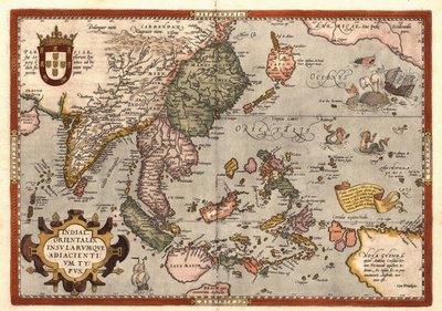
One of Franklin’s favorites along these lines is a map from 1570 of southeast Asia by the cartographer Abraham Ortelius (1527-1598). Japan is shown as an oval-shaped continent and to the east — for want of other details, one assumes — are depictions of mermaids combing their hair and sea monsters attacking a galleon. There are also several maps that depict what will later be named California as a long, thin island just off the coast.
You can find such oddities in special, pre-sorted groups by at the right of the main Web page where it says “More ways to explore the collection.” There, under the heading “Cartographic Curiosa,” Franklin explains, “These distorted depictions were often based on explorers’ erroneous reports or previous maps’ errors … (m)aps were sometimes slow to adjust to revisions based on continued exploration. For instance, one cartographer refused to depict California as anything but an island, even after verified accounts of its status as a peninsula had spread throughout Europe.”
In addition to the quirky curiosa and “California as an Island” groupings, there are similar subcollections under the headings “Exploration and Discovery” and “Northwest Passage.”
The digital collection is open to all, and includes the ability to zoom in close on areas to read fine print and enjoy the elaborate illustrations. It’s open, but Kinsey doesn’t see it as done — as new acquisitions come in, she said, they might be added later.
“These are compelling images,” Kinsey said, “and I think the history of the world seen through maps is a classic study, because you see the evolution of humans — the way people had to stretch their minds to try to discover what was on the horizon.”
Kinsey called the old maps “fascinating complements to our collection,” adding, “You know, we cover not just the Pacific Northwest but the world, and I think it’s important for people to know that we have a breadth to our special collections.”
To explore these vintage maps, visit online.


