April 28, 2009
Seaglider monitors waters from Arctic during record-breaking journey under ice
The University of Washington has surpassed its 2-year-old world record for operating a glider under the ice, this time by successfully operating one of its seagliders for six months as it made round trips hundreds of miles in length under the ice at Davis Strait.
The result contributes to the longest continuous measurement of fresh water exiting the Arctic through the Canadian Arctic Archipelago and Davis Strait and into the Labrador Sea.
Scientists worry that climate change may increase the amount of fresh water so much that it impacts the formation of very dense water in the Labrador Sea. That dense, cold water is a critical component driving the circulation of the world’s oceans, according to Craig Lee, a principal oceanographer with the UW’s Applied Physics Laboratory. Lee and senior oceanographer Jason Gobat lead the group developing the under-ice seaglider.
The UW group is the first and only one in the world sending gliders under the ice. Funded by the National Science Foundation, the UW has developed a glider able to:
- Consider how long it has been under the ice and how urgent it is to try to reach an opening in the ice to transmit its data;
- Use an internal ice atlas to weigh the odds of having open water above and then check as it rises to determine if the water temperature actually indicates whether ice is overhead. If conditions aren’t right and there isn’t an urgent need to download data, it just dives back down rather than chance damaging itself on the ragged underside of the ice;
- Sense an impending mechanical, electrical or communications failure and make a run for it — that is, try to get out from under the ice and into open water where it could relay its position and possibly be recovered.
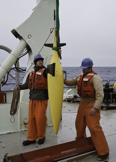
Seagliders developed by the UW School of Oceanography and Applied Physics Laboratory are small, reusable underwater vehicles meant to operate on their own, gliding without propellers from the surface to as deep as 1,000 meters, or 3,300 feet, while collecting such information as temperature, salinity and level of dissolved oxygen. When seagliders are at the ocean surface they can be commanded remotely from nearly anywhere in the world via the Internet and can transmit their data via satellite telephone. Unlike faster-moving propeller-driven autonomous underwater vehicles, which may need to be retrieved by ships only days after being deployed, UW seagliders can operate on their own for months at a time.
The ability to do so under ice, developed by Lee’s group, is important in a place such as Davis Strait where scientists want to measure how much fresh water flows through the strait and at what times of year so they have a baseline for comparison in coming years.
Early development of UW seagliders was paid for by the Office of Naval Research. The National Science Foundation funded work to add under-ice capabilities so it might take samples in hostile Arctic waters.
“This cutting-edge technology has the potential to make year-round measurements over broad areas where access by other means is severely limited, due to the presence of sea ice for part or all of the year,” according to Martin Jeffries, the foundation’s Arctic Observing Network program director.
In the latest deployment, two Applied Physics Laboratory seagliders went into the water Sept. 5. They relied on five sound sources in Davis Strait to figure out where they were and navigate once under the ice.
One operated for 25 weeks, spending 51 days and traveling more than 450 miles under the ice, before being collected Feb. 26 by the Danish Navy. During under-ice operations, the glider periodically sought small openings in the ice cover and succeeded in surfacing 10 times to transmit data. It made two round trips under the ice of about 230 miles each. Its journey was not as direct as desired on some legs because of weak signals from the navigation beacon and a now-known bug in the glider’s navigation system, Lee says. Still it collected an unprecedented record of fresh water moving through the strait.
The second glider operated as if it were in the open ocean because it dipped under the ice just before operators activated its “under-ice” mode. It then proceeded to prove the wisdom of Lee and his group’s decision that, when properly operating, their seagliders stay just a brief amount of time at the surface and transmit only priority data before diving back into the ocean. The errant seaglider wasn’t following that instruction: It surfaced in an opening in the ice and stubbornly tried to transmit all its data and ask for directions. It tarried too long, became frozen in the ice and couldn’t be retrieved.
Moorings — strings of instruments tethered to the seafloor — also are monitoring water in Davis Strait but are not ideal for detecting plumes of fresh water, Lee says. For one thing, the freshest water is often found in a thin layer about 50 meters thick, or 165 feet, just under the sea ice. Tethering an instrument atop a mooring so it reaches that thin layer puts the instrument at risk of being ruined if an especially thick, low-hanging piece of ice comes along and strikes it.
Seagliders pass through that upper layer as they dive from the top to the bottom of the strait and so can supply data in places that instruments on the mooring cannot, Lee says.
The seaglider project is one of more than 35 projects in the National Science Foundation’s Arctic Observing Network, which is meant to track and understand Arctic environmental change using an integrated suite of tools ranging from ocean buoys to satellites.
The Arctic Observing Network was one of the foundation’s primary research thrusts for the International Polar Year, which ended in late March. International Polar Year was a 24-month deployment by scientists from 60 countries to better understand the physical characteristics of the polar regions, their role as regulators of global climate and the nature of the changes occurring there as global temperatures rise. In the Arctic, scientists and Native communities also worked together not only to understand the changes themselves, but also the effects of change on subsistence lifestyles.
Collaborators on the Davis Strait project also include Richard Moritz, Kate Stafford and Beth Curry, UW Applied Physics Laboratory; Brian Petrie, Bedford Institute of Oceanography, Halifax, Canada; and Kunuk Lennert and other scientists, Greenland Institute of Natural Resources.
###
For more information:
Lee, 206-685-7656, craig@apl.washington.edu
Peter West is a public information officer with the National Science Foundation
Dena Headlee, is an audio visual production specialist with the National Science Foundation. A video news release about the seaglider containing sound bites from Lee and footage of the seaglider is available. Contact Headlee, 703-292-7739, dheadlee@nsf.gov.


