May 4, 1999
Evidence found for three prehistoric Everett-area earthquakes
Western Washington’s two major earthquakes this century had minimal impact north of Seattle. But new evidence suggests that in the previous 1,100 years an area between Everett and Marysville experienced at least three earthquakes of at least moderate intensity that produced liquefaction.
The events also produced at least one tsunami and one sudden ground level change, Jody Bourgeois, a University of Washington associate professor of geological sciences, reported today (May 4) in Seattle at the Seismological Society of America annual meeting.
Bourgeois and Sam Johnson of the U.S. Geological Survey in Denver collected data from the Snohomish River delta indicating one of the liquefaction events happened about the same time that land levels dropped as much as 2 feet in places and a tsunami rolled through Possession Sound between Everett and Whidbey Island.
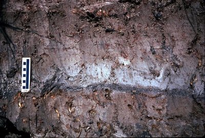
The land-level change was determined from changes in fossil vegetation, and a thin layer of sand in the delta’s sedimentary layers is evidence of a tsunami. Radiocarbon dating indicates those events happened between A.D. 800 and 950, and the scientists say they are linked to a large earthquake on the Seattle fault, 30 miles to the south.
Evidence presented to the seismological society by Brian Atwater, a UW affiliate professor of geological sciences and USGS geologist, narrows the timing for a major Seattle fault earthquake to between A.D. 900 and 930.
There are indications on the Snohomish River delta of two other liquefaction episodes – in which severe shaking essentially turns ground to liquid – but there isn’t yet enough data to correlate them with specific faults or earthquakes, Bourgeois said. Those events appear to have happened between A.D. 900 and 950 and again between 1450 and 1620.
The evidence suggests seismic hazards in the northern Puget Sound region that have previously been unrecognized and could have broad implications, Bourgeois said.
For instance, a large earthquake could cause major traffic disruptions, particularly if liquefaction occurs. Two heavily used highways (including Interstate 5) and the Burlington Northern and Santa Fe Railway line, which carries Amtrak traffic, cross several bridges as they pass through the Snohomish delta.
In addition, sewage treatment facilities for both Everett and Marysville are on land that could be subject to liquefaction in a large earthquake.
“Ground failure is one of the biggest effects of earthquakes, and we have evidence that ground failure occurred on the Snohomish delta prehistorically,” she said.
It is unclear whether any of the evidence is related to two nearby seismic systems, the Whidbey Island fault to the south and the Devil’s Mountain fault to the north. Recent work by Johnson and others has helped delineate those faults. Bourgeois next intends to search on Whidbey Island for sedimentary evidence of earthquakes and tsunamis.
She and Johnson, who earned a geological sciences doctorate at the UW, gathered their data from the Snohomish delta in 1997 and 1998. Their work followed a magnitude 5.3 earthquake near Duvall, in northeast King County, on May 2, 1996, the largest earthquake in the Seattle area since a magnitude 6.5 temblor in 1965.
“The Duvall earthquake woke people up to looking for evidence of prehistoric earthquake activity farther north,” Bourgeois said. “The work to that time had focused on central and southern Puget Sound because that’s where the historical record had been revealed.”
###
For more information, contact Bourgeois at (206) 685-2443 or jbourgeo@u.washington.edu


