
Part Three: Core Samples Help Explain Complex Geology
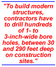
Urban geology also has its upsides. "At least some of the buildings contain coffee shops! A true advantage to working in the city," says Troost. In addition to caffe lattes, Troost and Booth also have access to data and technology that most field mappers can only dream about. To build modern structures, contractors have to drill hundreds of 1- to 3-inch-wide bore holes, between 30 and 290 feet deep on construction sites.
The drilling produces vertical shafts of rock—a cross section of the geology that lies beneath. Geologists then analyze the data, looking at groundwater conditions, density of the deposits and where different layers occur. For example, the first round of borings for Sound Transit's light rail line found an ancient channel that ran east-west under the north end of Capitol Hill. Subsequent drilling found four parallel ancient channels that were naturally filled in by glacial and nonglacial deposits. The rising cost of the light rail tunnel under Capitol Hill and Portage Bay can be blamed, in part, on these deposits.
Usually this data just sits in a file drawer. "The people who obtain this information generally do not have the time or money to do a thorough and broad analysis. Kathy and Derek are able to go far beyond what most of us can do," says Bill Laprade of the geotechnical consulting firm Shannon & Wilson. "By integrating the disparate data and analyzing it across the city, they make it far more valuable to the general public."
These cores are helping Troost and Booth, in concert with other geologists, to clarify one of the most complicated and troublesome aspects of Seattle geology: which rocks make up the city's famed hills, an important concern because not all rocks are made the same. For instance, some act as a sieve, allowing water to flow through them, while other rocks block the flow of water, which can oversaturate the layer above and weaken it.
A quick synopsis of our recent geologic past explains the complexity of our hills. Around 15,000 years ago, a 3,000- to 4,000-foot-thick ice sheet flowed out of Canada, moved as far south as Olympia, stalled there for about 500-1,000 years, and then began to retreat, leaving behind three distinct rock layers. The oldest and lowermost unit is known as Lawton Clay, 80 feet or so of dark gray, relatively impermeable clay and silt. Sediment settling into a quiet lake, which formed far in advance of the ice sheet, produced this layer, which can be seen in the lower cliffs of Discovery Park.
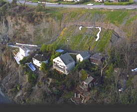
Landslides along Magnolia Bluff in Seattle during the winter of 1996. Photo courtesy Washington State Department of Ecology.
As the glacier crept south, streams carried material away from the ice snout and deposited a 120-foot-thick layer of poorly consolidated sand and silt, the Esperance Sand, on a flat plain in front of the ice sheet. During our notoriously wet winters, the highly permeable Esperance can become oversaturated because water cannot percolate into the underlying clay. This reduces soil strength and allows the sand to glide along the Lawton Clay. Most of Seattle's landslides occur along the contact zone between the Lawton Clay and Esperance Sand. Discovery Park's cliffs also hold examples of this layer.
A concrete-like bed of impermeable hardpan tops the pile. Known to geologists as Vashon-age Till, it often looks like poorly mixed concrete and consists of up to 30 feet of gravelly sand with scattered cobbles and boulders. Till is a direct product of the base of the glacier grinding the Puget Sound area into bits. Landslides also occur at the Esperance Sand/Vashon Till contact.
If geology were predictable, then a "typical" Emerald City knoll would look like a layer cake, with till atop sand atop clay, but the cores show that the subsurface geology is "predictable in its unpredictability," says Booth. The Magnolia neighborhood's landslide zone along Perkins Lane offers a fine example of this problem. "The Esperance is missing here, and one might expect this to be a more stable location because the till generally forms a coherent and enduring substrate," says Troost.
"What we find, however, is that the till has numerous lenses of sand that effectively transmit ground water, creating zones of weakness in otherwise strong material. Second, the site lies at the edge of an older, larger landslide that involves not only the filled material at the foot of the slope but several lots to the northwest," says Troost. "Thus a landslide hazard map predicated exclusively on the location of the sand-clay contact would not have identified this site as a zone of elevated hazard."
Go To: Page 1 | Page 2 | Page 3 | Page 4 | Page 5
- Sidebar: The Quake on Montlake
- Return to June 2001 Table of Contents